National Ag News
Much cooler, drier air ahead for the Heartland
Jul 19, 2019, 11:11 AM
by
Ann Gregson
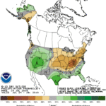
A short-lived heat wave will end during the weekend across the Plains and upper Midwest, and early next week in most other areas east of the Rockies.
Widespread showers and thunderstorms will precede
and accompany the surge of cool, dry air, with some of the heaviest rain
(locally 2 to 4 inches or more) falling in parts of the Southeastern and
Mid-Atlantic States. Elsewhere, monsoon-related showers will develop across the
central and southern Rockies and the Desert Southwest, while mostly dry weather
will prevail from the Pacific Coast to the northern Plains.
Continue reading Much cooler, drier air ahead for the Heartland at Brownfield Ag News.


