National Ag News
A wet, active pattern continues across the Heartland
Jun 20, 2018, 07:17 AM
by
Admin B
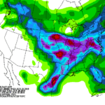
A wet pattern will prevail during the next few days along a west-to-east axis stretching from the central Plains into the Mid-Atlantic region.
The heaviest rain will occur along a slow-moving cold front that will generally separate hot, humid weather across the South from cool, dry air across the nation’s northern tier. A low-pressure system migrating eastward along the front will further help to focus rainfall, which could total 2 to 4 inches or more from Nebraska to the central Appalachians.
Continue reading A wet, active pattern continues across the Heartland at Brownfield Ag News.


