National Ag News
Moisture, chilly air to dominate much of the Heartland
Mar 28, 2018, 10:35 AM
by
Admin B
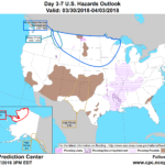
Rain across the nation’s mid-section will gradually shift eastward in conjunction with a slow-moving cold front, reaching the Atlantic Seaboard by Friday. Additional precipitation could total 2 to 4 inches, with locally higher amounts, from eastern Texas into the Ohio and Tennessee Valleys. During the weekend, a storm system traversing the nation’s northern tier will produce rain and snow from the northern Plains into the Northeast. Meanwhile, dry weather will prevail during the next 5 days in the West, except for some light precipitation in the Pacific Northwest and northern and central Rockies.
Continue reading Moisture, chilly air to dominate much of the Heartland at Brownfield Ag News.


