National Ag News
Extended cold wave pattern headed for the Heartland
Dec 20, 2017, 13:46 PM
by
System
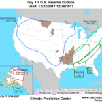
Southeastern showers will diminish as a storm system currently centered over the northern Delta races east. Meanwhile, a strong cold front will push southward across the Plains over the next couple days before reaching the East Coast over the upcoming holiday weekend. Showers associated with the front will be light on the central and southern Plains, while locally heavy upslope snow develops behind the front across the central and northern Rockies. By Friday, colder-than-normal conditions across the Great Plains will contrast with lingering warmth from the Texas Gulf Coast to the Southeastern and Mid-Atlantic States.
Continue reading Extended cold wave pattern headed for the Heartland at Brownfield Ag News.


