National Ag News
Cold pattern to dominate much of the Corn Belt
Dec 5, 2017, 14:00 PM
by
System
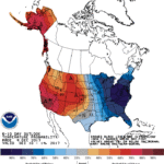
Markedly cooler to colder air will continue to overspread the Midwest, South, and East in the wake of a cold front’s passage. The front will stall across the Deep South, contributing to 5-day rainfall totals that could reach 1 to 2 inches. Accumulating snow can be expected, starting later Tuesday, across southern sections of the Rockies and High Plains. Meanwhile, snow showers will develop downwind of the Great Lakes. Late in the week, a secondary surge of cold air will maintain below-normal temperatures across the eastern half of the U.S., while warmth will build from the Pacific Coast to the High Plains.
Continue reading Cold pattern to dominate much of the Corn Belt at Brownfield Ag News.


