National Ag News
Not only excess rainfall, but frost & freeze concerns mount
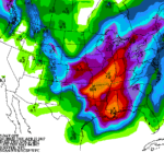
A fairly impressive spring cold snap will affect much of the western and central U.S. during the next few days. Although chilly air is already in place from the Pacific Coast to the Mississippi Valley, even colder air will surge across the nation’s mid-section in the wake of a departing storm system. That storm, which will arrive on the southern Plains by Saturday and reach the Great Lakes region on Monday, could lead to heavy rain (locally 4 to 8 inches or more) and flooding from the southeastern Plains into the mid-Mississippi Valley; severe thunderstorms from the southern Plains and mid-South into the Ohio Valley; and snow in the central and southern Rockies and adjacent High Plains.
Continue reading Not only excess rainfall, but frost & freeze concerns mount at Brownfield Ag News.


